
|
||||||||||||||||||||||||||||||||||||||||||||||||||||||
| Our Special Weather Center | Broadband Version | |||||||||||||||||||||||||||||||||||||||||||||||||||||
| Weather for Selected |
Flashplayer 6.0 or higher and Javascript required to view weather feeds
|
Special Net Locations | ||||||||||||||||||||||||||||||||||||||||||||||||||||
| Our Special Net's WEATHER CAMS | Current Weather Forecasts | Page seeks updated data every 90 seconds | ||||||||||||||||||||||||||||||||||||||||||||||||||||
|
National Composite NWS Radar Loop
EVERYTHING ELSE WeatherWise! 


|
|||||||||||||||||||||||||||||||||||||||||||||||||||||
| Weather Radio Feeds may not always be available. There is short stream loading time. NWS Radar Imagery may be intermittent at times... This imagery typically lags realtime by 7-12 minutes. | ||||||||||||||||||||||||||||||||||||||||||||||||||||||
| http://www.cocorahs.org/ CoCoRaHS logo Copyright © 1998-2005, Colorado Climate Center | ||||||||||||||||||||||||||||||||||||||||||||||||||||||
| Back to top | ||||||||||||||||||||||||||||||||||||||||||||||||||||||
|
Selected Locations Daily Streamflow Arkansas Colorado Big Thompson River, Loveland Cache La Poudre, Fort Collins Kentucky Dix River, near Danville Elkhorn Creek, near Frankfort Kentucky River, Lock 4, Frankfort Kentucky River, Lock 7, Highbridge Missouri New Jersey New York Ohio Texas |
Daily Streamflow Conditions
lower
> > >
higher
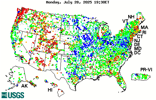 http://waterdata.usgs.gov/nwis/rt
 |
|||||||||||||||||||||||||||||||||||||||||||||||||||||
| Back to top This is a 12 week animated graphic at 5 second image intervals. | ||||||||||||||||||||||||||||||||||||||||||||||||||||||

|
||||||||||||||||||||||||||||||||||||||||||||||||||||||
| Back to top | http://www.drought.unl.edu/dm/monitor.html | 12 Week Animated Loop | ||||||||||||||||||||||||||||||||||||||||||||||||||||
 |
||||||||||||||||||||||||||||||||||||||||||||||||||||||
| Kentucky Roadway Information System Latest data from Interstate 64 Kentucky River Bridge at Frankfort, KY | ||||||||||||||||||||||||||||||||||||||||||||||||||||||
| Back to top | ||||||||||||||||||||||||||||||||||||||||||||||||||||||
|
Our Special Net Weather Feeds powered by CoffeeCup RSS NewsFlash 4.5 |
||||||||||||||||||||||||||||||||||||||||||||||||||||||
|
EMAIL OSN anti-spam powered by
Our Special Net Gean-ealogy.com Chatham History 26thNC OSN Images Sparkles2Rhythm The CHIPS Group Odes OSN Weather OSN Search About Our Special Net |
||||||||||||||||||||||||||||||||||||||||||||||||||||||

